Bagyong Auring, bahagyang humina; Maraming lugar sa bansa nananatiling nasa ilalim ng Signal no. 1
Bahagyang humina at bumagal ang bagyong Auring habang kumikilos West, Northwest.
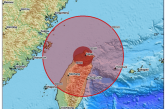
Sa latest forceast ng Pag-Asa, namataan ang sentro ng bagyo sa layong 335 kilometers Silangan ng Hinatuan, Surigao del Sur.
Taglay nito ang lakas ng hanging aabot sa 65 kilometro kada oras malapit sa gitna at pagbugso ng hanggang 80 kph.
Nananatiling nasa ilalim ng Tropical Cyclone signal no.1 ang maraming lugar sa bansa:
Sorsogon, Masbate including Ticao and Burias Islands, Albay, Catanduanes, and the eastern portion of Camarines Sur (Caramoan, Presentacion, Sagnay, Buhi, Iriga City, Nabua, Bato, Balatan)Northern Samar, the rest of Eastern Samar, Samar, Biliran, Leyte, Southern Leyte, Cebu, Bohol, Siquijor, Negros Oriental, the northern and central portions of Negros Occidental (Kabankalan City, Himamaylan City, Binalbagan, Isabela, Moises Padilla, Hinigaran, La Castellana, Pontevedra, San Enrique, La Carlota City, Pulupandan, Valladolid, Bago City, Murcia, Bacolod City, Talisay City, Silay City, Enrique B. Magalona, Victorias City, Manapla, Cadiz City, Sagay City, Escalante City, Toboso, Calatrava, San Carlos City, Salvador Benedicto), the eastern portion of Iloilo (San Rafael, Barotac Viejo, Lemery, Ajuy, Sara, Concepcion, San Dionisio, Batad, Estancia, Balasan, Carles), and the eastern portion of Capiz (Roxas City, Panitan, Ma-Ayon, Cuartero, Dumarao, Panay, Pontevedra, President Roxas, Pilar) Surigao del Sur, Agusan del Norte, Agusan del Sur, Davao Oriental, Davao de Oro, Davao del Norte, Davao City, Camiguin, Misamis Oriental, and Bukidnon.
Signal No. 2:
Central and southern portions of Eastern Samar (Sulat, Taft, San Julian, Borongan City, Maydolong, Balangkayan, Balangiga, Lawaan, Llorente, Hernani, General Macarthur, Quinapondan, Giporlos, Salcedo, Mercedes, Guiuan)Dinagat Islands and Surigao del Norte including Siargao and Bucas Grande Islands.
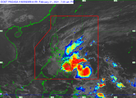
Heavy Rainfall: Today (21 February): Moderate to heavy rains with at times intense rains over Dinagat Islands, Surigao del Norte, and Surigao del Sur. Moderate to heavy rains over Eastern Visayas, Misamis Oriental, Bukidnon, Camiguin, and the rest of Caraga. Light to moderate with at times heavy rains over Bicol Region, MIMAROPA, Zamboanga Peninsula, Quezon, the northern portion of Davao Oriental, Davao de Oro, and the rest of Visayas and Northern Mindanao.• Tomorrow (22 February): Light to moderate with at times heavy rains over Bicol Region, MIMAROPA, Western Visayas, Northern Samar, Samar, Eastern Samar, Quezon, Aurora, Isabela, and Cagayan.• Under these conditions, scattered flooding (including flash floods) and rain-induced landslides are likely during heavy or prolonged rainfall especially in areas that are highly or very highly susceptible to these hazards as identified in hazard maps. Adjacent or nearby areas may also experience flooding in the absence of such rainfall occurrence due to surface runoff or swelling of river channels. PAGASA Regional Services Divisions may issue local thunderstorm/rainfall advisories and heavy rainfall warnings while the Hydrometeorology Division and River Basin Flood Forecasting and Warning Centers may issue General Flood Advisories and Basin Flood Bulletins as appropriate.
Strong Winds: In the next 24 hours, the combined effects of the surge of the Northeast Monsoon and Tropical Storm “AURING” will bring gale-force winds in areas under Tropical Cyclone Wind Signal (TCWS) #2 and strong breeze to near-gale conditions with occasionally higher gusts over the areas where TCWS #1 is in effect, as well as over CALABARZON, MIMAROPA, Aurora, and the rest of Visayas and Bicol Region.Hazards affecting coastal waters:•
In the next 24 hours, rough to very rough seas will be experienced over the seaboards of areas under TCWS (2.6 to 5.0 m) and the eastern seaboard of Luzon not under TCWS (2.6 to 4.5 m). Rough seas (2.5 to 4.0 m) will prevail over the southern seaboard of Luzon (including the eastern seaboard of Palawan), the remaining seaboards of Visayas, and the northern, eastern, and western seaboards of Mindanao that are not under any TCWS. Sea travel is risky for all types of sea vessels over these waters.• Moderate to rough seas (1.2 to 3.0 m) will be experienced over the remaining seaboards of the country. Mariners of small seacrafts are advised to take precautionary measures when venturing out to sea. Inexperienced mariners should avoid navigating in these conditions.
(DOST Pag-Asa FB Page)